


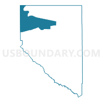
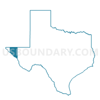
Voting District 003N, Hudspeth County, Texas
About
Outline

Summary
| Unique Area Identifier | 674901 |
| Name | Voting District 003N |
| County | Hudspeth County |
| State | Texas |
| Area (square miles) | 469.35 |
| Land Area (square miles) | 469.35 |
| Water Area (square miles) | 0.00 |
| % of Land Area | 100.00 |
| % of Water Area | 0.00 |
| Latitude of the Internal Point | 31.75790120 |
| Longtitude of the Internal Point | -105.76768640 |
Maps

Graphs
Select a template below for downloading or customizing gragh for Voting District 003N, Hudspeth County, Texas


Neighbors
Neighoring Voting District (by Name) Neighboring Voting District on the Map
- Voting District 0001, Hudspeth County, TX
- Voting District 0002, Hudspeth County, TX
- Voting District 0004, Hudspeth County, TX
- Voting District 003S, Hudspeth County, TX
- Voting District 0155, El Paso County, TX
- Voting District 0156, El Paso County, TX
- Voting District 0157, El Paso County, TX
- Voting District 0158, El Paso County, TX
- Otero County Precinct 2, Otero County, NM
- Otero County Precinct 3, Otero County, NM
Top 10 Neighboring County Subdivision (by Population) Neighboring County Subdivision on the Map
- El Paso East CCD, El Paso County, TX (160,404)
- Southeast Otero CCD, Otero County, NM (13,108)
- Fort Hancock CCD, Hudspeth County, TX (2,057)
- Dell City CCD, Hudspeth County, TX (761)
- Sierra Blanca CCD, Hudspeth County, TX (658)
Top 10 Neighboring Unified School District (by Population) Neighboring Unified School District on the Map
- Alamogordo Public Schools, NM (43,326)
- Clint Independent School District, TX (41,811)
- Fort Hancock Independent School District, TX (2,226)
- Dell City Independent School District, TX (620)
- Sierra Blanca Independent School District, TX (613)
Top 10 Neighboring State Legislative District Lower Chamber (by Population) Neighboring State Legislative District Lower Chamber on the Map
- State House District 75, TX (219,408)
- State House District 74, TX (143,566)
- State House District 54, NM (30,120)
Top 10 Neighboring State Legislative District Upper Chamber (by Population) Neighboring State Legislative District Upper Chamber on the Map
- State Senate District 19, TX (766,044)
- State Senate District 29, TX (758,901)
- State Senate District 34, NM (45,445)
Top 10 Neighboring 111th Congressional District (by Population) Neighboring 111th Congressional District on the Map
Top 10 Neighboring Census Tract (by Population) Neighboring Census Tract on the Map
- Census Tract 9.02, Otero County, NM (9,941)
- Census Tract 103.35, El Paso County, TX (3,991)
- Census Tract 9503, Hudspeth County, TX (3,476)
- Census Tract 103.44, El Paso County, TX (3,430)
- Census Tract 105.02, El Paso County, TX (2,281)
- Census Tract 103.19, El Paso County, TX (641)